Hope Street is a long stretch of a road, and not every design choice or improvement is relevant to every section of the street.
As such, we've broken our design for improving Hope Street into 8 sections.
These sections are split between key intersections and will be delivered at different points in the future. Some sections contain improvements that will be made by Council alone. Other sections involve changes that will require external approvals or advocacy by Council for external delivery.
Click on the map to view the sections and learn more about them below.
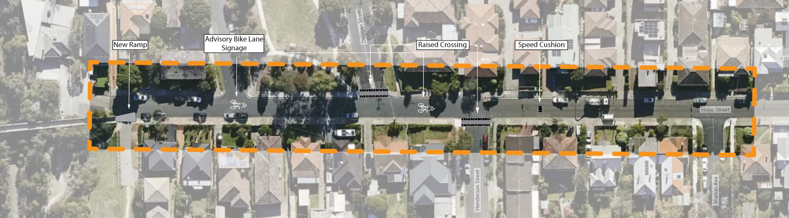
The proposed designs for this section of Hope Street focus on calming traffic and improving pedestrian safety, especially at the busy intersections with Duggan Street and Henderson Street.
The design includes:
- Raised Crossings at Duggan Street and Henderson Street
- Installation of speed cushions
- New signage to direct people riding bikes on the street
- Installation of a new and improved ramp onto the shared use bridge over City Link for people walking and riding bikes
It is anticipated that these upgrades could be delivered in the medium term (1-2 years).
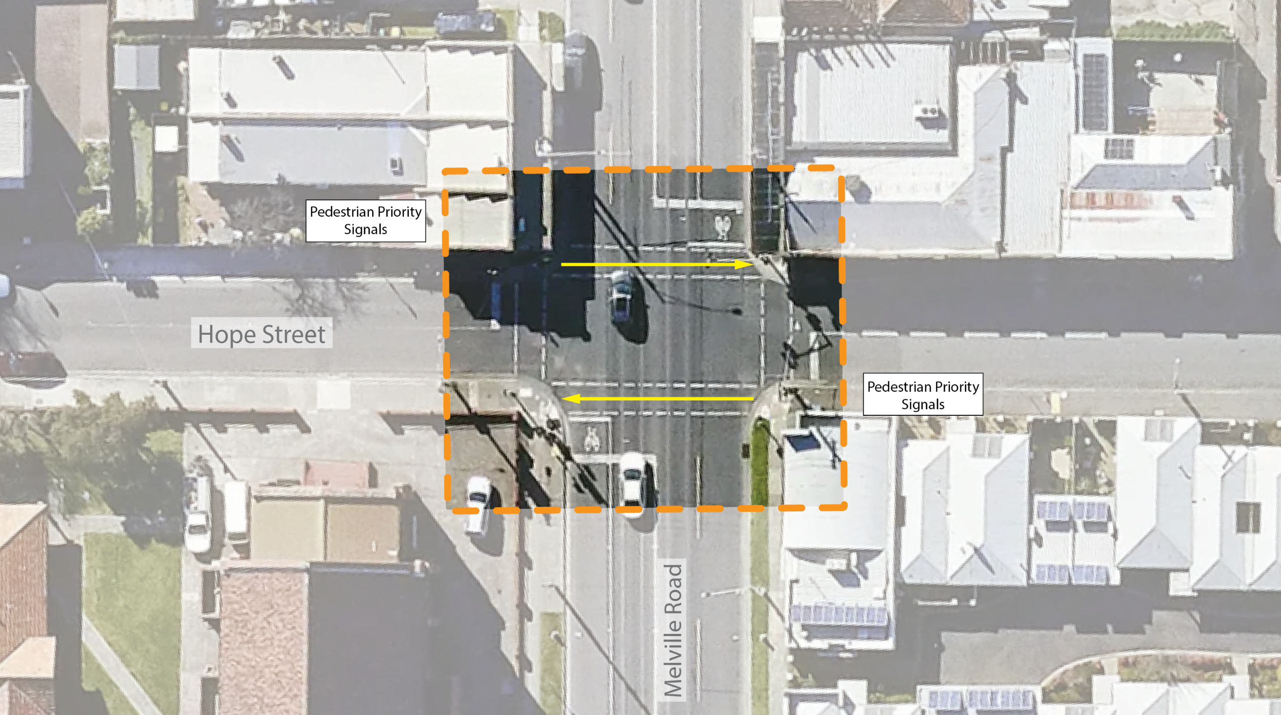
The proposed designs for this section of Hope Street are focussed on improving access and safety for people walking and riding and creating a better flow of traffic for all road users using this intersection.
These designs include:
- New priority pedestrian and bike crossing signal at this intersection to give pedestrians and riders safer opportunity to cross the street.
Please note that Melville Road is a State Government controlled road and any proposed changes to how this intersection functions require approval from the Department of Transport and Planning.
Council will advocate to the Department to add a priority pedestrian and bike rider crossing signal at this intersection.
It is anticipated that signal changes to this intersection could be delivered in the short term (1 year).
Additional traffic lanterns for bike riders would require further funding and approval and could be delivered in the longer term (2+) years.
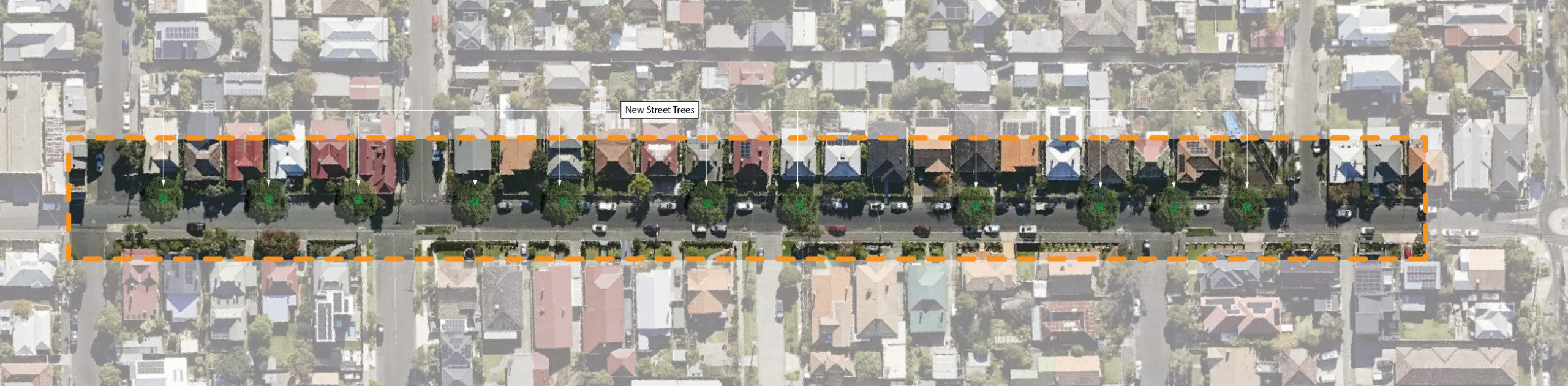
The proposed improvements for this section of the street focus on greening and tree planting. The trees will be planted so that as they mature, they will provide significantly increased shade through canopy cover.
This is currently the section of Hope Street with the least amount of greenery and shade.
This includes:
- Tree planting in the roadway in place of car parking. Exact car parking changes would be determined during the detailed design phase of this project
- Approximately 15-20 trees planted
- Retaining the existing bluestone characteristics of this section of Hope Street with the use of tree pits
It is anticipated that these upgrades could be delivered in the short term (1 year) and would form part of the first round of works to be completed on Hope Street.

The designs for this section of the street propose trialling a road closure to addresses safety concerns at the Pearson Street and Hope Street roundabout. This is an unsafe intersection, especially for pedestrians attempting to cross the road, due to the high volume of traffic moving through it.
The design includes:
- Seeking to undertake a trial road closure for the eastern Hope Street leg of the intersection to reduce the volume of non-local traffic travelling along Hope Street as a rat run or short cut
- Allowing people walking and riding bikes to move through the road closure
- Maintaining property access for local car traffic
The process for undertaking a trial road closure requires further work and approval, including reports to Councillors and dedicated community consultation. Road closures must be trialled and monitored for 12 months before decisions regarding permanent infrastructure can be made.
Residents and community members will be consulted on the specifics of this trial at various intervals if we proceed with the proposal.
It is anticipated that this trial closure could be implemented in the medium term (1-2 years).
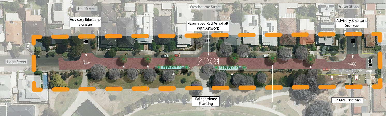
The proposed designs for this section suggest a range of improvements to create a safer, easier to use section of road, including road resurfacing.
This design changes in this section includes:
- Road resurfacing with coloured asphalt and a central, on-road artwork
- New signage to direct people riding bikes on the street
- Traffic calming speed cushions on side streets and Hope Street
- Tree planting on north side of street (approximately 4-6 trees)
- Installation of raingardens on south side of street adjacent to central entrance to oval
- Street furniture on south side nature strip adjacent to rain gardens to provide a place to sit and rest or enjoy the street
These designs directly address feedback from our first round of community consultation, in which our community shared that the road surface and poor condition along this section of Hope Street made it more difficult to use.
It is anticipated that these works could be delivered in the medium term (1-2 years).
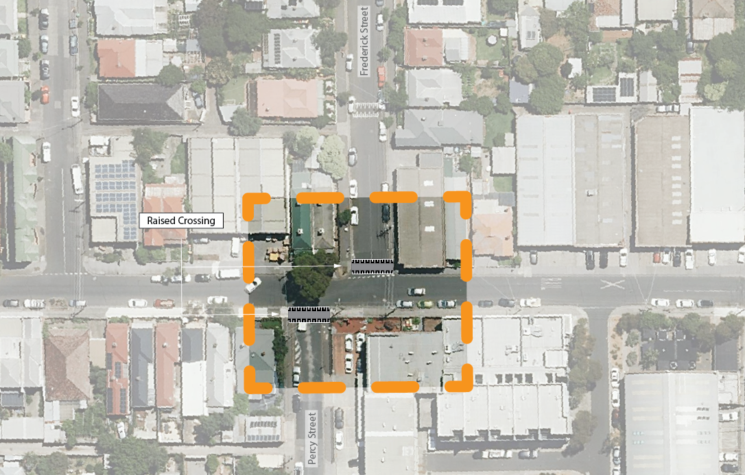
The proposed designs for this section aim to improve safety and traffic flow around Percy Street and Frederick Street, which are the busiest side streets along Hope Street.
During our first round of community consultation, we heard that this intersection was causing stress for our community, particularly for pedestrians.
To amend this, this design section proposes:
- Raised crossings for both Percy Street and Frederick Street
It is anticipated that these works could be delivered in the medium term (1-2 years).
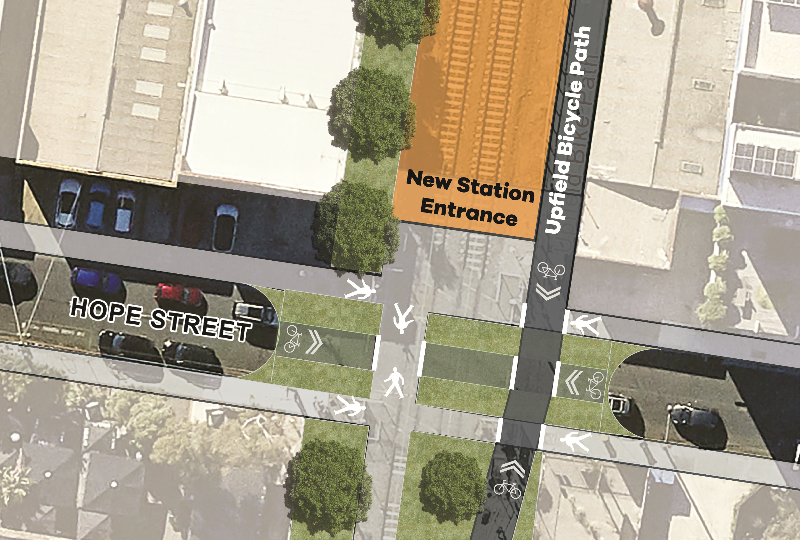
The proposed designs for this section of the street make improvements that will create safe and easy access to the new train station that will be created as part of the Victorian Government’s Level Crossing Removal Project (LXRP).
To achieve this, we will:
- Advocate to the LXRP to include a road closure in designs for Hope Street crossing and station entrance
- Allow pedestrians and bike riders to pass through closure
- Maintain property access for local car traffic
This work would be delivered by LXRP and currently there is no timeline for when this would be delivered.
Based on the last update for the Brunswick LXRP it is likely that this would be delivered in a long-term time frame (3 years+).
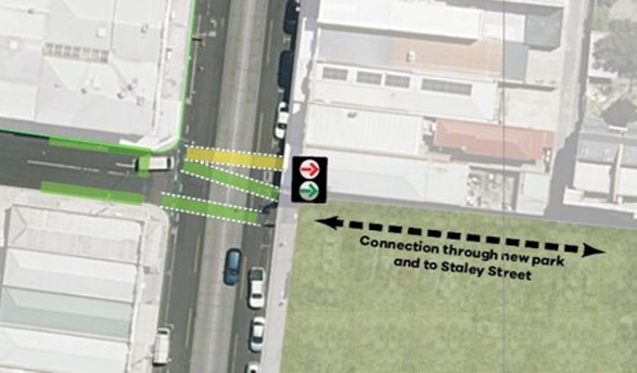
The proposed designs for this section of the street make improvements that create a safe connection to Stewart Street, continuing our Creek to Creek connection through Merri-bek, and allow better access to the new Park Close to Home at 568-574 Sydney Road.
Planning for improvements to Stewart Street are currently scheduled to commence in 2026, as part of our Streets for People Plan.
Planning for the new Park Close to Home at 568-574 Sydney Road is already underway. Community consultation on a design for the park is currently open. Find out more about the park and leave your feedback on the project page.
The improvements made to this section will provide benefits for all three of these projects, creating a harmonious street environment that allows all road users to move and visit easily and safely in this area.
To achieve this, we will:
- Advocate to the Department of Transport and Planning for a new set of signals to be installed at Sydney Road to allow vehicles to turn right out of Hope Street
- Advocate for pedestrian and bike rider operated signals which will provide a safe crossing across Sydney Road between Hope Street and the new Park Close to Home at 568-574 Sydney Road
- Create a safe and accessible connection from Hope Street to Staley Street and Stewart Street through the new park
Signal changes to this intersection could likely be delivered in the long term (2+ years).
Changes to how Sydney Road functions require external approvals from the Department of Transport and Planning and further investigation from Council.
As part of our improvements and upgrades, we are proposing a safer speed limit of 30km/h along Hope Street.
This change will support our interventions designed to slow traffic and reduce traffic volumes and rat running, creating a safer environment for all road users.
This change aligns with the Department of Transport and Planning's updated Speed Zoning Policy document which was released in August 2025.
That policy acknowledges the significant safety benefits of reduced speed limits on local streets and enables Councils to implement 30km/h speed limits within their municipality when certain conditions are met.
A 30km/h safer speed on Hope Street would not be instated until after Council completes installation of other traffic calming infrastructure as part of this project and trials the road closure at Pearson Street.
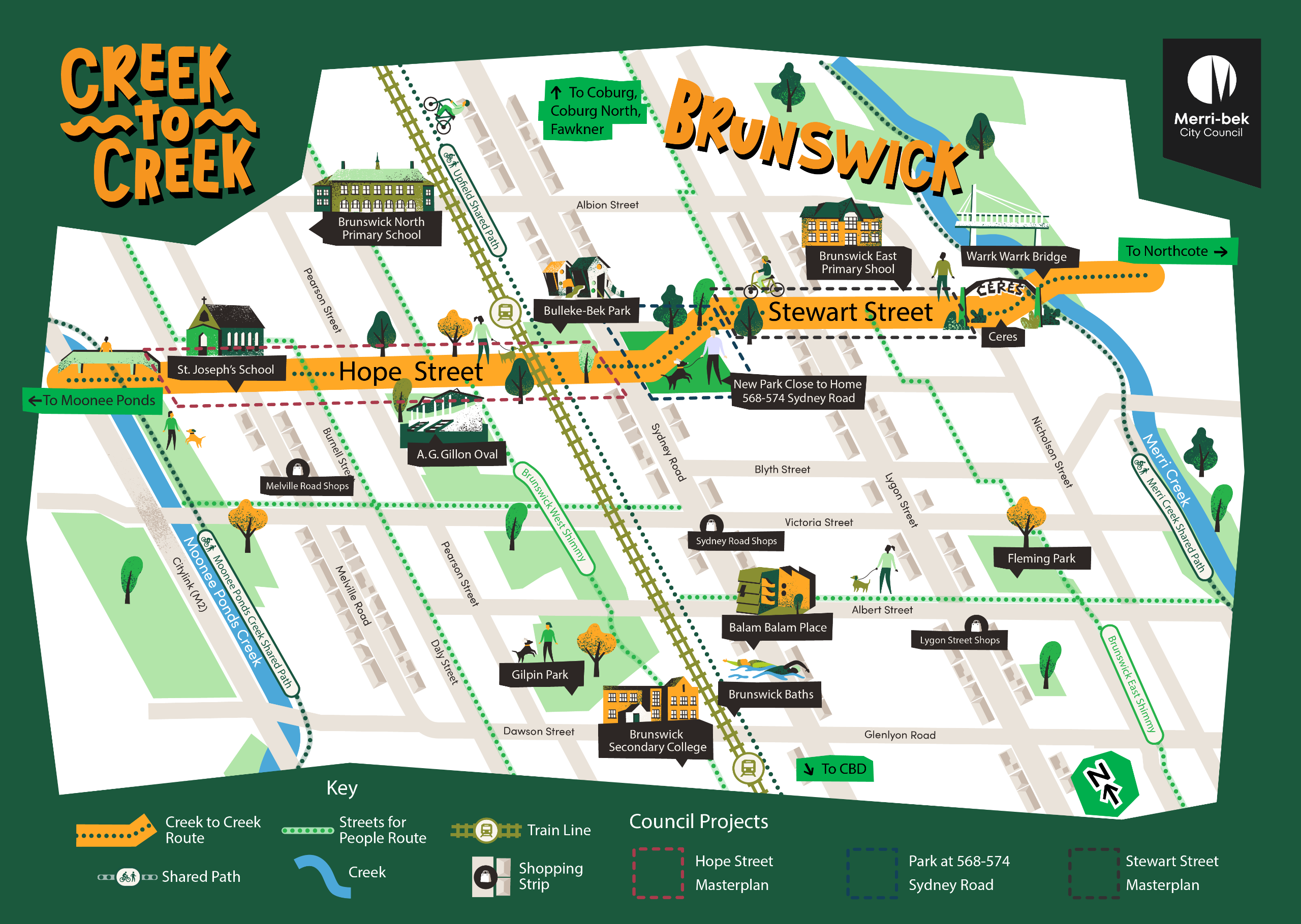
Creating a Creek to Creek route
In 2026, we will be commencing design work and community consultation on improving Stewart Street in Brunswick as part of our Streets for People Plan.
Its our vision that together, our proposed Hope Street improvements and future Stewart Street improvements would work together to create an intuitive, safe and accessible route that connects Moonee Ponds creek to Merri creek, enabling more people to safely travel east west through Merri-bek, something that we regularly hear can be difficult.
This 'Creek to Creek' route would also allow more people to easily get to the new Park Close to Home on 568-574 Sydney Road, that is a central point between Hope and Stewart Streets.
Frequently asked questions
Research shows that when a person walking or cycling is struck by a car, the likelihood of death is around 90 per cent at a vehicle speed of 50 km/h, about 40 per cent at 40 km/h, and only 10 per cent at 30 km/h.
The recent update to the State Governments Speed Zoning Policy permits local councils to use 30km/h speed limits on local streets without going through a trial process.
Conditions for 30km/h local streets require that they are part of a cycle network, safe walking routes to schools, or are near to public transport stations and have infrastructure and design features that support 30km/h travel speeds.
We are proposing a suite of changes for Hope Street that will facilitate slower vehicle speeds and improve road safety for all road users, particularly people who walk and cycle.
A lower speed limit for Hope Street will greatly contribute to making the street safer for people walking and riding bicycles, and by extension, all road users.
The 509 bus currently operates along Hope Street between Barkly Square and Pascoe Vale. This service runs hourly between 9am and 3pm on weekdays and does not operate on Sundays, other nearby routes such as the 508 on Victoria Street and the 503 on Albion Street offer more frequent services within 400 metres of the project area.
If the proposed road closure at Pearson Street proceeds, the 509 route will need to be either adjusted or suspended.
Council provides a community bus service which will be available to support eligible residents affected by any changes. Further details are available on our Support Services webpage.
During our community consultation period, we heard extensive feedback from the community letting us know there are excessive rat-running vehicles along the entire length of Hope Street. This was reflected in our traffic counts along the street.
Council is proposing a trial closure in the form of a modal filter with physical barriers that prevent non-local vehicles travelling along the street. People walking and cycling will still be able to travel through these barriers.
Modal filters are designed to reduce the volume of vehicles travelling along Hope Street, improve local noise and air pollution and increase safety for people walking and cycling.
Local traffic will still be able to use Hope Street to access all properties via the local street network.
Non-local vehicles would be diverted onto arterial roads that are designed to carry higher volumes of traffic
To proceed with a road closure at this location, Clause 10, Schedule 11 of the Local Government Act 1989 requires a formal public consultation procedure be followed enabling public submissions to be considered prior to any Council decision in accordance with Section 207A of the Act.
The Act grants the power to Council to place barriers on a road temporarily for a genuine traffic diversion experiment and requires Council to consider a report from the Department of Transport and Planning on the proposal.
Any proposed road closures on Hope Street will require additional public consultation processes prior to their installation.
No. The 2 30km/h trial zones are separate to Hope Street streetscape improvements, with the exception of the short section east of the Upfield train line within the Breese Street precinct.
During our community engagement, 48% of people who completed the survey reported that there are difficulties walking and riding bikes along Hope Street.
As such, we are proposing a combination of traffic calming measures and new advisory bike route signage. These changes will create a safer environment for people riding bikes while working within the confises of the street's width.
This design functions as a ‘greenway’ and is consistent with the bicycle infrastructure design guidance in Council’s Moving Around Merri-bek Transport Strategy and Streets for People Plan.
Hope Street is a narrow road, and does not have the required width to install bike lanes.
We undertook a first round of engagement in early 2025. We asked the community what their experience with Hope Street was, and what changes they would like to see.
This feedback directly informed our concept designs for this round of engagement.
In order to achieve the greening and tree planting requested by the community along Hope Street, some changes to car parking are required.
It is anticipated that only a small number of car parking spaces will be removed along the length of Hope Street.
These will be replaced with street trees, garden beds and rain gardens to improve the look and feel of the street, improve greenery and provide additional shade cover.
Ready to join the conversation?


